The last time I spent longer than a day hiking anything, I
was probably smaller than the backpack I was carrying. It would therefore not
be unreasonable to see committing to hiking the second tallest mountain in
Kenya over four days as highly optimistic.
To be precise, though Mount Elgon straddles the Kenya –
Uganda border, its highest peak is located entirely in our neighbor to the
west. This made it an ideal meeting place for our Easter weekend get together.
Friends in Zambia who used to live in Uganda were eager to come for a visit,
and another friend from Lusaka had recently moved to northern Uganda, while
Emily, our colleague and I were easily able to hop over from Bungoma. That’s
how we came to gather at the ominously named but enormously helpful Rose’s Last Chance outside of Mbale, Uganda one late March evening.
Rose, of Last Chance fame, helped us organize porters and
guides for our trek ahead of time, so we were in pretty good shape to leave the
next morning once we managed to cram all our supplies and cooking gear into our
packs. It was still early morning by the time we were taking our first steps
through villages and farms, heading towards the border of the national park.
To get the same feel of that first day, you could drag a
stairmaster out into the summer sunshine. Once we entered the park, things got
vertical fast. Eventually though, we entered the rain forest-esque zone and the
pitch of the ground flattened out some.
As we hiked up we passed through more zones; surprisingly
varied ecosystems stacked on top of one another. The higher we got, the more
the trees thinned out. The scrub was replaced by tall brown grass, fields of
it, dotted with prehistoric trees shaped like old multi-light street lamps.
Once we were up in the foothills of the mountain, these vistas rolled along to
either side of us, just high enough to keep the peaks out of sight.
We camped the first night at significant elevation and
prepared for a summit ascent in the early morning. “Summit ascent” carried a
certain weight in my mind, conjuring an image of ice axes, crampons and oxygen
tanks, but of course it was nothing like that. We started behind schedule, as
we did every morning, so consistently in fact that our guide started to work it
into our wake up calls. By the time we left the loose cover of the small grove
where we’d camped, the sun was stretching white rays across the brown grass. We
were bundled up even then, as the light didn’t chase away the chill, but we’d
come to learn how strong it could be at altitude.
By this time we could see the first, slightly shorter peak
that we would eventually skirt around. The climb was gradual, with only a few
short steep pitches, while the altitude was the real challenge. Our steps took
more attention, and it was amazingly easily to become winded. We were careful to avoid
overexertion and altitude sickness, and I certainly didn’t mind lots of little breaks.
At mid day we crested the ridge leading to Wagagai Peak, and
it was only an hour or so until we summited. The exact height of Wagagai is a
satisfying 4,321 meters (14,000 ft) above sea level, but the view wasn’t the precipitous
drop I had imaged. Instead, stretched around us were the rolling foothills we
had just navigated. Through a pass in the distance we could make out a village
our guide told us was in Kenya. Weary and accomplished, we sought out worn patches
of rock or little bits of grass to rest on. Enjoyable as that respite was, the
sun really worked us over, and I got some of the worst burns I’ve ever had. I
suppose the ridiculous outfits I had to sport afterwards for extra protection,
including gloves, were the silver lining for all of us.
We spent that night in the same campsite after descending
from the summit, and readied ourselves for the distance we’d need to cover the
next day to reach the other side of the mountain. It really was a trek: 33km
over rolling hills, climbing out of a gorge only to descend back into the next
one, then the next one, and so on. The views were stunning when we were on
hilltops and able to look down the long valleys. Crossing the caldera, the site
where this ancient volcano essentially imploded, we were ringed by tall
chimneys and jagged crests of red rugged rock protruding from the earth.
Most of us were feeling very weary when we finally stopped
for lunch, not halfway to our next campsite. The rest of the day was a blur of
sun, sweat and heavy breathing, but we finally allowed ourselves some optimism
upon entering the thickening brush signaling the end of the plateau and the
start of our descent.
Not too long after, running from a gathering storm that
thankfully never reached us, we were standing at the mouth of a massive cave,
Tutum Cave, with a stream of water falling front and center. It was here under
this water, with the waning light and the high chattering of the bats roosting
within, that we washed off days of dirt and sweat and cleaned the wounds
and blisters we now boasted. The campsite, though muddy to reach and infested
with ants, was inviting in the knowledge that it would be our last.
The following morning, squeezing bandaged feet into sodden
shoes, we started our final descent. The trees changed from bamboo forests to
thick vines and trunks, and the downhills became steeper and more direct. And
suddenly, the birdcalls were playing harmonies with chainsaws and we could look
down and see a town, and the edge of the park. At the gate we managed to haul
ourselves onto motorcycle taxis, which carried us at relatively astonishing
speed down the dusty roads to deposit us at a crumbling guesthouse near Sipi
Falls. We sat and admired one of these stunning falls, beer in hand, feet
released from their prisons, before treating ourselves to a real shower, a nice
meal, and a bed.
I've heard people refer to Type II fun, something you
don’t necessarily enjoy at all times throughout but look back on in a positive
light. I think this would qualify; certainly I can’t remember the last time I pushed myself that hard. But there’s a real sense of accomplishment in
traversing an entire mountain, especially when you think back on how far you’ve
come. Cliché as it sounds, this particular hike pushed me to enjoy the journey,
since the whole thing was a journey really, and to appreciate the subtle
changing beauty of our surroundings. Even with more realistic expectations, I’d
still set out on a trek like this again. Or maybe that’s the Type II fun
talking…
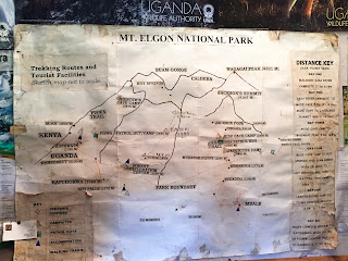
(We traveled from Budadiri, bottom right, up to Wagagai Peak, down to Tutum Cave, then exited through Forest Exploration Center)
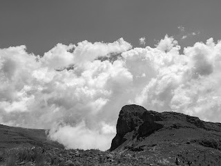
(The upper ecosystem, first peak visible in the distance)
(Circumventing the first peak)
(Post summit nap)
(Valleys stretching from the caldera)
(In the caldera. Photo by Jeff)
(Help with sun protection. Not pictured, my gloves. Photo by Jeff)
(Colorful little guy we ran into)


